Educational Adventures in Arizona

Discover Arizona's unique beauty, scenic diversity, and colorful history! We are a homeschool family that enjoys learning about Arizona’s history, geography, and environment while exploring every corner of the state together. We invite you to join us on our family’s adventures in Arizona, the Southwest, and beyond.

Saturday, September 08, 2007

LAKE CITY TO MONTROSE, CO ~ September 2, 2007

Lake City was named for nearby Lake San Cristobal. There are quite a few smaller lakes and a stream runs through there, too. We saw lots of beaver dams and lodges. The whole area is picturesque and unpopulated. Lake City is a well preserved turn-of-the-century town. It’s one of Colorado’s largest historical districts, with over 75 buildings from the late 1800’s. I would have loved spending some time walking around Lake City’s charming downtown and admiring its quaint Victorian architecture. As one of the most isolated 19th-century Colorado mining camps, Lake City is still a quiet little town in the middle of nowhere, a perfect getaway destination from civilization.

From Lake City we headed north on Hwy. 149 to Blue Mesa Reservoir. Created by Blue Mesa Dam, the 20-mile long fiord-shaped reservoir is Colorado’s largest body of water, with 96 miles of shoreline. The road skirts alongside of it, so we got to see the lake from one end to the other. The most amazing thing was, on this huge lake hardly anyone was there on a beautiful 70º Labor Day weekend! We saw one sailboat and a few other boats, but Arizona lakes are way more crowded than this one! Their facilities include two marinas, three boat launches, and a National Parks Service visitor center with displays. There are hiking trails, too.

The Black Canyon of the Gunnison begins below Blue Mesa Dam. The deepest and most dramatic section of the canyon is preserved as a National Park. The Black Canyon is so steep and narrow that the walls are cloaked in dark shadows because sunlight doesn’t reach them. The Gunnison has one of the steepest river descents in North America, dropping an average of 43 feet per mile, and as much as 240 feet per mile at Chasm View. (In comparison, the Colorado River through the Grand Canyon drops an average of 7.5 feet per mile.) On the north side of the canyon is Painted Wall, the highest sheer cliff in Colorado at 2,250 feet. There is a scenic drive along the south rim, a campground and several miles of hiking and nature trails. The canyon is also popular with rock climbers. It’s not the place to go if you’re scared of heights, however! We didn’t have time to stop there but I shudder just thinking of it!

Cimarron is a small community on the Cimarron River, just south of the Black Canyon of the Gunnison National Park. We passed by the Cimarron Shooting Club, and a place that resembled a Pioneer Village with old buildings to walk around. From there to Montrose it’s wide open prairie for the most part. Montrose is the largest town in the area. Incorporated in 1882, it became an important shipping center with the Denver & Rio Grande railroad as well as a branch railroad line serving the mineral-rich San Juan Mountains to the south.

Montrose has an airport and is gateway to the world-class ski resort Telluride as well as the exclusive Valhalla Shooting Club & Training Center on the grounds of the five-star Elk Mountain Resort. VSC features a 16,000 square foot indoor pistol facility with a state-of-the-art automated shooting range and a two-story 360-degree live fire scenario house. The computer-controlled lighting, sound effects, and props were created with the assistance of Broadway stage designers. Realistic scenario rooms include a subway station, bedrooms, kitchen, bar, nightclub, industrial area, a warehouse, the first class section and cockpit of an airliner, and many other fully furnished settings.

This is a great concept and it’s worth checking out the video on their website at www.valhallatraining.com, but Valhalla is certainly out of our price range. A lifetime membership costs something like $60,000! (Norman Schwarzkopf and Kareem Abdul-Jabbar are members.) It’s open to day visitors, but members and resort guests have priority. If you were to just take a two-day class it would cost around $500 per person. Then they will let you stay at the resort for a special “reduced rate” of only about $300 per night. There is an on-site restaurant, but even that will average $30/plate. Hmm, is it really a progressive one-of-a-kind educational facility or more like a reality-based playground for the rich and famous?

Labels: , , , , , , ,

Sunday, June 03, 2007

EL MORRO, NM ~ May 27, 2007

Just west of El Malpais National Monument on Highway 53, is El Morro National Monument. Between these two parks, simply marked with a little sign, is the Continental Divide. This is the natural geologic and hydrologic north-south boundary that runs through North America, separating the Atlantic Ocean watershed from the Pacific Ocean watershed.

When we were driving to El Morro I didn’t know what to expect so after a while I was wondering if we had passed it. But I found out that it’s impossible to miss this landmark from the highway! El Morro – “the headland” or “the fortress” – was quite impressive even from a distance. About 15 miles west of the Continental Divide, in the middle of a high desert plain you suddenly come upon a huge rock formation looming 200 feet above the surrounding landscape. It reminded me of El Capitan at Yosemite, CA.

So it’s a large rock, what’s the big deal you say? Well, there is much more to it than that! El Morro’s prominence actually has more to do with history than geology. This sandstone monolith sheltered an oasis that attracted Anasazi, Spanish, and American travelers throughout a 700-year period. Just go to the Visitor Center and find out all about it. The building is set up like a museum with exhibits and a video to watch, which provide an overview of El Morro’s significance at the “Crossroads of the Southwest.”

To begin with, an ancient Indian route between the Acoma and Zuni pueblos led directly past El Morro. Then sometime in the late 13th century, Anasazi Indians built an 875-room pueblo on top of the bluff. It was an easily defensible spot, inaccessible to outsiders, with a shaded pool at the base of the cliff for a dependable year-round water source. The pool also attracted coyotes, deer and other wild creatures. Rain and snow melt kept the pool filled to the brim, with cattails growing at the water’s edge. However, after a couple of generations the Anasazis abandoned that site for unknown reasons as they did others in the Southwest. Their petroglyphs of bear tracks, human hands, and other symbols can still be seen on the sandstone wall.

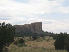
Following the Indians came the Europeans. El Morro became as much of a landmark and water source for the Spanish conquistadors as it was for the natives. Not everyone left a message, but the first known historical mention of El Morro is found in the journal of Diego Pérez de Luxán. He traveled with the Espejo Expedition, which stopped there for water on March 11, 1583. Don Juan de Oñate, the first Spanish Governor of Northern New Spain, carved his name with the words “pasó por aqui” (“passed by here”) on April 16, 1605.

In 1680, the Pueblo Indian revolt drove the Spaniards from New Mexico. Twelve years later, Don Diego de Vargas, the most famous governor of New Mexico, restored order and left this message at El Morro: “Here was the General Don Diego de Vargas, who conquered for our Holy Faith and for the Royal Crown all of New Mexico at his own expense, year of 1692.” (At that time, the province of New Mexico extended roughly from the border of Louisiana to the border of California.)

Many more explorers, soldiers, Indian agents, surveyors, pioneers, and settlers stopped at El Morro. These include: Dominguez-Escalante (1776), De Zuñiga (1795), Young (1829), Sitgreaves (1851), Whipple (1853), Doniphan (1846), J.H. Simpson and R.H. Kern (1849), sheep drives to and from California (1830-1880), and military wagons (1840-1880). It was on August 23, 1859, when an Army expedition led by Lieutenant Edward Beale passed by El Morro as they sought to survey a wagon road from Texas to California. Beale’s entourage included 25 Egyptian camels being tested as pack animals. Their wrangler, P. Gilmer Breckinridge, also left his signature on the rock.

After the Beale wagon road was established, so many visitors passed by this site as they headed westward toward California, that the Inscription Rock at El Morro was almost as popular as Register Cliff (Guernsey, WY) along the Oregon Trail. The Prescott to Santa Fe stagecoach line also ran by El Morro from 1863-1882. This road continued to be the major route west until a railroad line was built about 20 miles to the north and travelers no longer depended on the water supply at El Morro.

The inscriptions at El Morro range from ancient petroglyphs, to simple scratchings, to elaborate scripts, to etchings by professional tombstone carvers. Some of the older carvings were even overlapped by newer ones. While at one time it was desirous to carve your name in the inscription rock, today you’re not allowed to touch any of the carvings or add your own. Since 1906 when the site was proclaimed to be a National Monument, it’s been closed to all new rock writings due to the historical significance of this stone document. But just outside the visitor center they provide a large chunk of soft sandstone for those who can’t resist the urge to see their name written in stone.

There is a $6.00 per person admission charge at El Morro to go out on the trail. (They will give you a detailed booklet that translates the Spanish engravings and explains each person named.) It’s an easy, half-mile, one-hour or less self-guided walk to see the pool and inscriptions. A more strenuous two-mile hike leads to the Indian pueblos on top of the bluff. But even if you don’t venture any further, you can learn a lot at the Visitor’s Center museum for free. It was getting late in the day when we were there and none of us felt like walking any more after our long hike at El Malpais, so we just stayed in the museum and watched the movie about it. But next time I definitely want to go back there and take the trail!

Labels: , , , , , ,